Canada's Redefined Supply Chain
If you look at a map of the U.S. supply chain network, you'll see a dense, complex web. Highways and rail lines crisscross the country, connecting dozens of major hubs in a resilient, multi-directional network designed to limit disruption and costs, while constantly improving flexibility and resiliency. Now, look north of the 49th parallel where the map of Canada’s primary supply chain has historically looked very different. It was, for all intents and purposes, a long, thin line — a single corridor running parallel to the US border, tethered to the Trans-Canada Highway and the main east-west rail lines of CN and CP (now CPKC).
But this map is being enhanced in real-time, and for those occupying or involved in the industrial real estate world, understanding this shift is critical.
The old map made cities like Calgary and Winnipeg profoundly important, yet their role was often underestimated. To many, they were simply regional distribution centers nestled in the Canadian prairies. In reality, they were the critical interchange points holding the entire national network together. A product moving from Vancouver to Toronto didn't have multiple route options; it had to pass through Calgary and flow through Winnipeg. These cities weren't just serving their local populations; they were the essential nodes in a linear system, the vital organs along a single artery.
This linear model always had a critical point of failure: its overwhelming reliance on the Port of Vancouver. As North America’s most land-constrained and expensive industrial market, Vancouver has long struggled with congestion. From the COVID bottlenecks that began in 2020, to the Vancouver floods of late 2021 that severed all rail and highway links between the port and the rest of Canada, this vulnerabliity was laid bare. While long-term plans for Prince Rupert were already in motion, these compounding factors served as a dramatic, real-world stress test that proved its necessity. This strategic shift is now taking concrete form in the newly opened CANXPORT Logistics Park. This multi-billion dollar project isn't just about adding more cranes to a terminal; it's a plan to build a fully integrated, state-of-the-art logistics ecosystem with facilities for warehousing, transloading, and distribution right on-site. It represents a monumental investment poised to exponentially increase the port’s container capacity from 1.6 million TEUs (Twenty-Foot Equivalent Units) currently available at DP World’s Fairview Container Terminal, to nearly 2.5 million TEUs annually, proving that Prince Rupert is being built out as a core component of a more resilient national supply chain.
This is where the story gets interesting, and where the map truly begins to change with the strategic rise of the Port of Prince Rupert. It all comes down to a simple fact of geography: the shortest distance between Asia and North America isn’t a straight line—it’s a curve. That curve puts Prince Rupert 500 nautical miles closer to key Asian ports than any other gateway. For a container ship, that’s a big deal. It shaves 36 hours off the trip compared to Vancouver and a massive 68 hours—nearly three full days—off the journey to Los Angeles.
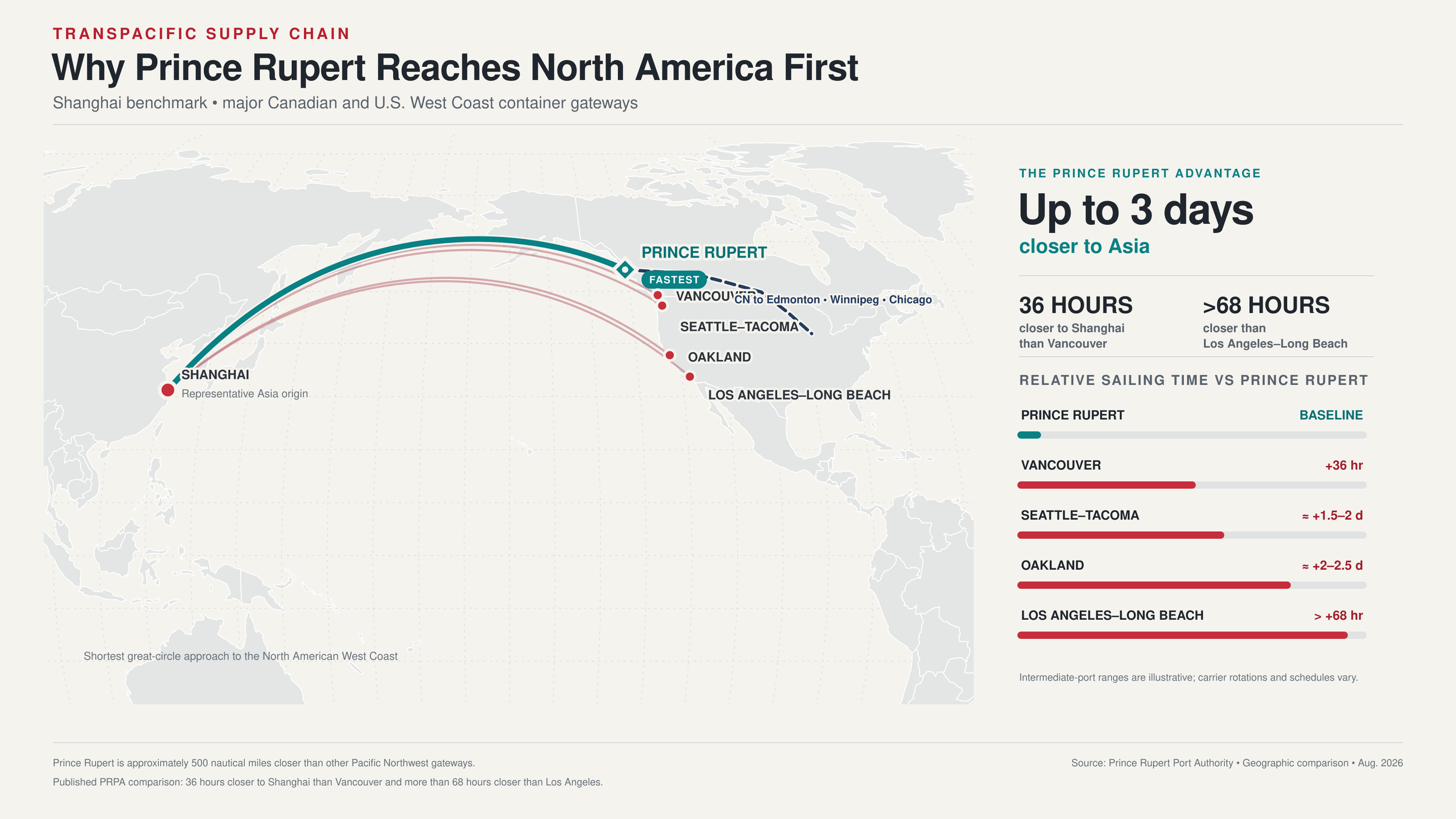
But the time savings don't stop at the water's edge. While ships can spend days anchored in queues off the coast of Southern California, Prince Rupert’s uncongested harbor means they pull right up to the dock. From there, it’s a direct handoff to CN’s dedicated rail line, creating a high-speed, uninterrupted pipeline straight into the U.S. Midwest. The bottom line? Cargo landing in Prince Rupert can reach Chicago up to four days faster than shipments moving through the Southern California ports. It's an advantage of pure velocity.
The ripple effect of this shift is profound, and it flows directly east into Alberta. As more goods from Asia land in Prince Rupert and move inland on CN’s line, the cities of Edmonton and Calgary are being transformed. They are no longer just interchanges on an east-west line; they are becoming the first major inland sorting and distribution hubs for this new, powerful stream of international cargo. This has given rise to Alberta’s status as a burgeoning inland port. Capital is following suit, with hundreds of millions of dollars being invested in massive new distribution centers in industrial parks like Acheson and Nisku in the Edmonton Region, and Balzac in the Calgary Region. Absorption has been immense, with millions of square feet of new, state-of-the-art warehousing built in the last 5 - 10 years specifically to capture this flow, and no expected slow down on the horizon.
For occupiers, developers, and investors, this is the new reality of Canadian logistics. The nation's supply chain is evolving from a fragile line into a more resilient, multi-artery system with options for businesses looking to effectively and efficiently manage their supply chains. The industrial buildings going up in these inland hubs aren't just boxes for storing goods; they are the essential nodes in a reconfigured, continent-spanning network. They are the physical manifestation of a more diversified, robust, and strategically intelligent supply chain.
One thing Canadians often lack is options, and the growth of the Port of Prince Rupert is providing just that, an alternate path on a global supply chain network that is desperate for safe, quick and reliable alternatives. And who knows, perhaps the next pathway on this more comprehensive Canadian supply chain map leads us directly to Churchill, Manitoba and the Hudson Bay…